
Short answer: the deed says where it is, and a surveyor finds it.
Real answer: Your property line is where your deed and the recorded plat put it. A licensed land surveyor is the one who finds it on the ground. Online maps, county parcel lines and old fences are only clues. In Seattle and across King County, check the free county records first. Then hire a licensed surveyor before you build, plant or argue anywhere near the line.
Property line finder
Find your line: what you have, where to look, and whether you need a surveyor
Pick what you’re planning, where the home is and what you already have. You’ll see how strong your clues are, the free records to check in your county, whether it’s time for a licensed surveyor, and a plan you can tick off.
How strong are your clues?
Free records to check
Your plan
Based on Washington’s Survey Recording Act (RCW 58.09), surveyor licensing (RCW 18.43), boundary statutes (RCW 58.04) and county recording guidance. The 10-year date is general information, not a finding that any claim exists; adverse possession and boundary acquiescence need much more than time. Not legal advice; talk to a real estate attorney about a dispute.
A fence should bring privacy and calm, not 10 years of cold stares across the yard. I’ve watched a survey settle in an afternoon what neighbors had argued about for years. I’ve also seen how rarely the fence sits on the line. As I tell clients, surveys are surprisingly uncommon. People spend $10,000 to $15,000 on a fence without one, and it’s surprising how many fences are not on the actual borders. How far from the line you can build is its own question; my setbacks guide covers the distances.
The basics
What a property line is in Washington, and what only looks like one
On paper first, then on the ground
The line is defined on paper, then marked on the ground. Your deed’s legal description points to a recorded plat (lot and block) or a written description of distances and bearings. A licensed surveyor finds the monuments those records refer to, measures, and marks your corners. Everything else is a clue of some strength.
Why online maps are only clues
King County says it plainly on its own assessor maps: they’re for assessment, “not guaranteed to show accurate measurements,” and not for survey purposes. The same is true of every app built on parcel data.
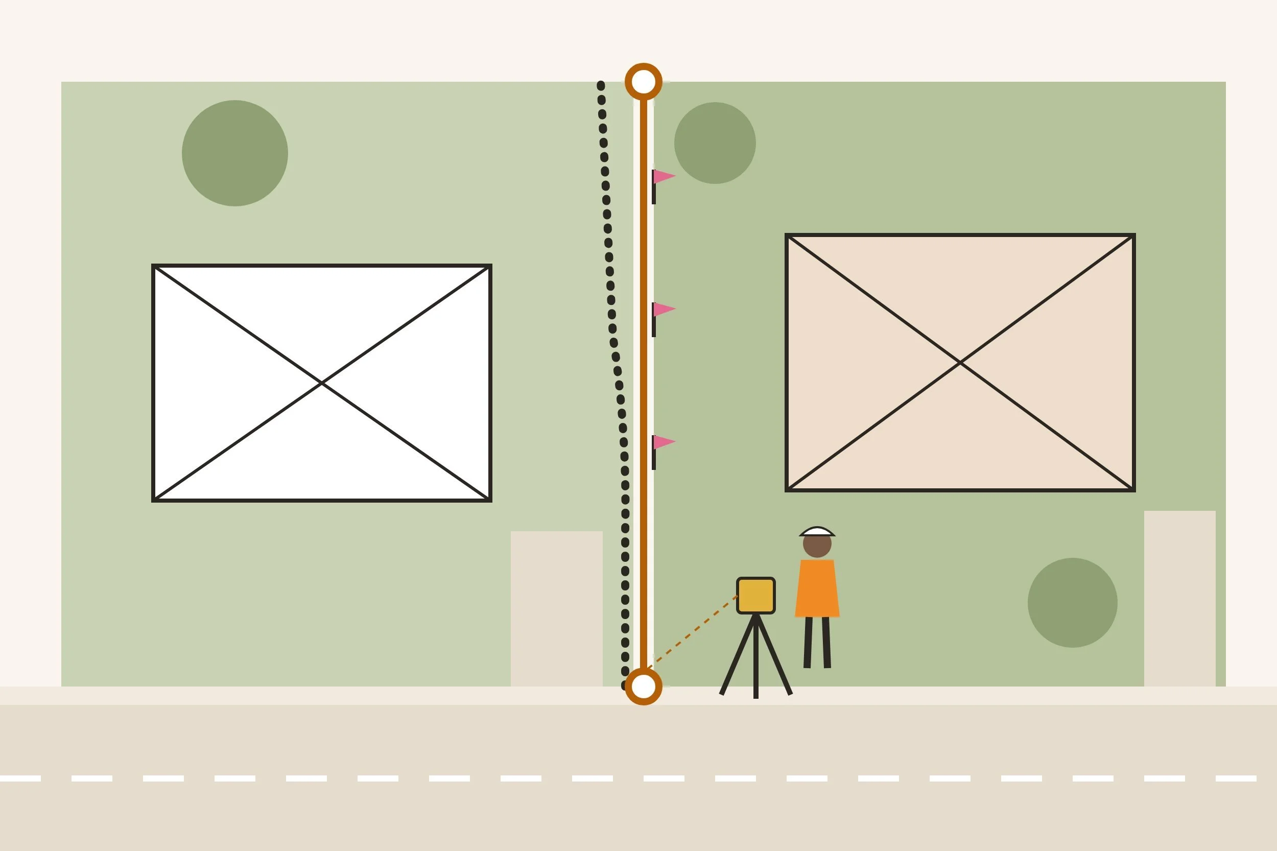
- 1The surveyed line runs straight between the corner pins a licensed surveyor finds or sets.
- 2The county map line is drawn for taxes. It can sit a few feet off, and skew.
- 3The old fence went where someone built it. Here it crosses the line near the back.
| Clue | What it tells you | Build to it? |
|---|---|---|
| Online map or app | A rough outline drawn from county tax parcels; approximate | No |
| County parcel or assessor map | Lot shape and dimensions for tax purposes | No |
| Recorded plat | Lot dimensions and the original monuments, on paper | No, it needs a surveyor to put it on the ground |
| Title report | Recorded easements, surveys and agreements; not where the line sits | No |
| Old fence, hedge or wall | Where someone once built; can be inches or feet off | No, and it can signal a claim |
| Pins you find | Strong, if a licensed surveyor set them and nobody moved them | Only after a surveyor confirms |
| A recorded survey | A licensed surveyor’s map of the corners | Usually, once the corners are re-staked |
| A new boundary survey | Current corners, staked and mapped for you | Yes |
Free records
Start with free records: where to look in King County and nearby
Before you pay anyone, find out what already exists. A survey may have been done by a past owner, the builder, or the neighbor, and many are public. King County calls a title report the best way to see whether a survey was recorded on your property. The one from your purchase lists recorded surveys, easements and boundary agreements in Schedule B.
- 1Look up your parcel on the King County Parcel Viewer and copy the legal description. It names your plat, lot and block.
- 2Search recorded surveys. King County has recorded private surveys since 1973; the King County Archives guide walks through the Recorder’s online system, Landmark, and the Parcel Viewer’s scanned surveys. Surveys recorded before August 1, 1991 aren’t viewable online, but the Archives can send a copy.
- 3Pull up the plat for your lot and block. All recorded King County plats are digitized on Landmark.
- 4Find your title report from the purchase and read Schedule B for surveys, easements and boundary agreements.
- 5Ask the neighbors on each side whether they’ve ever had a survey. Theirs shows the shared line too.
| County | Where to search | Good to know |
|---|---|---|
| Seattle and King County | Recorder’s Office records, via the Archives guide | Private surveys since 1973; plats on Landmark |
| Snohomish County | Auditor recorded document search | Most documents since July 1976 online; a free account is required since March 2, 2026; use the Legal search for surveys |
| Pierce County | Auditor recorded documents and map search | Index and images of recorded maps online, plus a map search |
| Thurston County | Auditor online record index | Search a survey by the requester’s name or by section, township and range |
| Anywhere in Washington | State Digital Archives, plats and surveys and DNR Public Land Survey Office | The state collects and indexes survey records |
Curious what your house looked like before the fence went up? The same county records help with that; my historical photos guide shows where to look.
Corner pins
Looking for the corner pins yourself
What a corner pin looks like
Surveyors mark corners with monuments built to last. It's usually a length of rebar or pipe with a plastic or metal cap, set just below the ground. Washington requires every monument a surveyor sets to carry that surveyor’s certificate number. A cap you can read tells you who set it, and their map tells you why.
Look before you pay twice
A client was once quoted over $5,000 to resurvey land that had been surveyed 10 years earlier. I told them what I tell everyone. The stakes are long gone, but rebar a surveyor drove 10 years ago is usually still there, a few inches down. The old map and a metal detector are the place to start.
- Bring the map.Measure from a known corner along the distances on the survey or plat, then search that spot.
- Use a metal detector.In my experience caps sit 2 to 6 inches down, under sod, bark or a fence post.
- Check the cap.A license number means a surveyor set it. A bare pipe or wood stake proves little.
- Don’t move it.A disturbed monument helps no one. Washington’s Public Land Survey Office handles permits before survey monuments are removed.
- Confirm before you build.A pin can belong to an older survey, a different lot, or a corner that was knocked loose. A surveyor can confirm it quickly.
Surveys
When to hire a licensed land surveyor, and what you get
When you need one
Hire a surveyor whenever being wrong would cost real money. Think of a fence, a wall, a driveway, an addition or ADU, or trees near the line. A neighbor who disagrees, or a purchase where the yard matters, counts too. Only a licensed professional land surveyor may survey land in Washington. You can check any license in a minute on the state license lookup.
Many surveys become public
Many new surveys end up in the public record. Say a survey sets corners that didn’t exist, or finds a corner that differs materially from the record. Then the surveyor must record it with the county within 90 days.
- 1Send 3 surveyors your address, parcel number, any old survey and what you’re planning. Ask for a written scope and price.
- 2Expect a wait. Surveyors book up in the dry months, and some ask for payment up front to hold a date.
- 3The office pulls the deed, plat and nearby surveys, then a crew finds the monuments that control your block.
- 4The crew sets or recovers your corners, often with rebar and a capped stake, and can add offset stakes for a fence.
- 5You get a signed map, usually as a PDF, a week or more after fieldwork. It’s recorded with the county if the law requires it.
- 6Keep the map with your house papers. It answers Form 17 when you sell and saves the next owner the cost.
| Survey | What it is | Good for |
|---|---|---|
| Boundary survey | Corners found or set, with a map of the lot and what’s on it | Fences, disputes, buying, additions |
| Line staking | Stakes along the line or offset from it, with a simple exhibit map | A fence or hedge on a lot that was surveyed before |
| Record of survey | A boundary survey recorded with the county auditor | Anything you want on the public record |
| Topographic survey | Ground elevations, trees and structures | Building permits and drainage plans |
| ALTA/NSPS survey | A detailed survey built to a national standard for title insurers and lenders | Commercial or high-value deals |
What it costs, from my own files. Quotes for a regular Seattle city lot have run about $1,350 (2019) and $2,300 (2025, line staking with an exhibit map and no permanent markers). A rural lot with an older survey drew bids over $5,000. Timing on my own rural land was about 7 weeks to the field date and 7 more to the signed map. Your price depends on the lot, the records and the season, so get 3 quotes.
Fences and trees
Fences, walls and trees near the line
Once you know the line, you still choose where the fence goes. I use both approaches. On one property I have more than a thousand linear feet of fence on the line, and I paint both sides with the neighbors’ blessing. At my Seattle home, one run sits 3 feet inside my line so I can maintain it without asking anyone.
| On the line | Fully on your side | |
|---|---|---|
| Needs the neighbor’s yes | Yes, in writing | No |
| Who maintains it | Usually shared | You |
| Yard you keep | All of it | A little less; leave room to paint and repair |
| If you part ways later | Harder to replace or remove | Your call alone |
- Put the agreement in writing.For a fence on the line: who pays, who maintains, and what happens if one of you sells.
- Know the old fence law.Washington’s partition fence statute says a neighbor who uses your boundary fence to enclose their own land owes half its value. It dates to farm country; ask an attorney before you lean on it.
- Mind the trees.Cutting or damaging a tree on someone else’s land without permission can mean triple damages under Washington law. Get the line first, and ask before you prune across it.
- Check height and setback rules.My setbacks guide has Seattle’s fence heights and how close sheds, decks and additions can sit. My privacy design post has ideas once you know where you can build.
Disputes
When you and a neighbor disagree about the line
Get the facts before the conversation. A survey turns an argument about feelings into a conversation about a map, and most of the time that’s where it ends. In older Seattle neighborhoods it isn’t rare to learn that a house, garage or driveway sits right at the line, or slightly over it. Many of these get solved with a written easement or agreement rather than moving anything.
- 1Survey. If the neighbor doubts it, offer to share the map, or split the cost of one survey you both trust.
- 2Talk. Bring the map, not a demand. Most issues are a fence, a planter or a parking pad a foot over.
- 3Put it in writing. Washington lets neighbors fix a boundary by a signed, acknowledged agreement with a survey map, recorded with the county; it binds future owners.
- 4Change the line if you both want to. Moving a line is a lot boundary adjustment, a permit from the city or county (in Seattle, SDCI).
- 5If it doesn’t settle, an attorney. A court can establish an uncertain boundary and may order mediation first.
| How a line can change | What it takes | Time |
|---|---|---|
| Adverse possession | Use that is exclusive, actual and uninterrupted, open and notorious, and hostile (treating the land as your own, without permission) | 10 years |
| Possession with color of title | Possession under a good-faith paper title, while paying the property taxes | 7 years |
| Mutual recognition and acquiescence | A clear line on the ground (often a fence) that both owners treated as the boundary, proven by clear, cogent and convincing evidence | 10 years |
| Boundary line agreement | A signed, acknowledged agreement with a survey map, recorded with the county | When recorded |
| Lot boundary adjustment | A permit that moves a line without creating a new lot | When approved and recorded |
2 things the old “10-year rule” leaves out. First, permission defeats a claim, so a friendly written “use it, it’s still mine” matters. Second, a court can make the winner of an adverse possession case reimburse the property taxes the owner paid. This is general information, not legal advice. Talk to a real estate attorney about your facts.
Buying and selling
Buying or selling: where the property line shows up
The seller disclosure
Washington doesn’t require a survey to buy or sell a house. Instead, the seller disclosure, Form 17, asks 2 questions under Title. Are there any encroachments, boundary agreements or boundary disputes? And is there a boundary survey for the property? Sellers answer what they know; “don’t know” is an honest answer.
Title insurance
Title insurance is the other place it shows up. A standard owner’s policy excludes “encroachments, or questions of location, boundary and/or area which an accurate survey may disclose.” A Washington appeals court upheld that exception when owners later found a neighbor’s structure on their side of the line. Broader coverage is available, often with a survey. My title insurance post explains the basics.
What to do about a boundary question during a sale is strategy. That lives in my client guides: the buyer guide’s due diligence chapter and the seller guide’s prep chapter.
FAQ
Frequently asked questions about property lines in Seattle
How do I find my property line for free?
Look up your parcel’s legal description, then search the county’s recorded surveys and plats. Read Schedule B of your title report, and ask the neighbors whether they have a survey. In King County, private surveys have been recorded since 1973. Those records tell you what exists; a surveyor puts it on the ground.
Can I see my property lines on Google Maps or an app?
You can see an outline, but not the line. Apps draw county tax parcel data over aerial photos, and the counties say that data isn’t for survey use, so treat it as approximate.
Can my phone find my property line?
A phone’s GPS is fine for a rough guess, like where to look for a pin. It isn’t accurate enough for a fence, a wall or a neighbor conversation.
How accurate are county parcel maps?
Good enough to find your lot, not to build on. King County’s assessor maps say they aren’t guaranteed to show accurate measurements and shouldn’t be used for survey purposes.
How much does a property survey cost in Washington?
It depends on the lot, the records and the season. Quotes I’ve seen for a regular Seattle city lot ran about $1,350 in 2019 and $2,300 in 2025; a rural lot drew bids over $5,000. Get 3 written quotes with the scope spelled out.
How long does a survey take?
Fieldwork is usually a day or two. Booking can take weeks, especially in summer, and the signed map often follows a week or more after fieldwork. On my own rural land it was about 3 months start to finish.
What is the 10-year fence law in Washington?
It usually means adverse possession or mutual recognition and acquiescence. Both can move ownership to the neighbor after 10 years, but only when strict conditions are proven. A fence alone isn’t enough, and permission defeats adverse possession.
Can a neighbor take my land just by using it?
Only if the use is exclusive, open, uninterrupted and without your permission for 10 years, and a court agrees. Keep the line marked, use your land, and put any permission in writing.
Who pays for a fence on the property line?
Whoever agrees to. Put it in writing. Washington’s old partition fence law says a neighbor who uses your boundary fence to enclose their land owes half its value. Ask an attorney whether it fits your case.
Is a survey required to sell a house in Washington?
No. Form 17 asks whether a boundary survey exists and whether there are encroachments or boundary disputes. Lenders and title insurers may ask for one in some deals.
Who can locate my property corners?
A licensed professional land surveyor. It’s unlawful to practice land surveying in Washington without a license. Check the license on the state lookup and look for the surveyor’s stamp on the map.
How close to the property line can I build?
That depends on your zone and the project. My Seattle setbacks guide has the current distances and a checker.
The bottom line
Records tell you what exists, a licensed surveyor tells you where it is, and a written agreement keeps the peace. Check the free county records first, read your title report, look for pins, and hire a surveyor before you spend money near the line.
If you’re about to build a fence or you’ve found something odd along the line, send me a note. I’m glad to look at the records with you and point you to the right help.
Sources
- Land use recorded documents: plats and surveys, King County Archives
- Surveys, plats and condos, King County Recorder’s Office
- Assessor quarter section map (disclaimer: do not use for survey purposes), King County Department of Assessments
- Search recorded documents, Snohomish County Auditor
- Recorded documents, Pierce County Auditor
- Look up property records, Thurston County Auditor
- Public Land Survey Office, Washington State Department of Natural Resources
- RCW 58.09.040, Records of survey (filing within 90 days), Washington State Legislature
- RCW 58.09.120, Monuments marked with the surveyor’s certificate number, Washington State Legislature
- RCW 18.43.010, Registration required to practice land surveying, Washington State Legislature
- License lookup, Washington State Department of Licensing
- RCW 4.16.020, Ten-year limit on actions to recover real property, Washington State Legislature
- RCW 7.28.070, Possession under color of title with taxes paid, Washington State Legislature
- RCW 7.28.083, Adverse possession: reimbursement of taxes, costs and fees, Washington State Legislature
- Chase v. Ebeling, No. 68439-6-I (2013), citing Chaplin v. Sanders on the elements of adverse possession, Washington Court of Appeals
- Vanderhoof v. Mills, No. 70343-9-I (2013), on mutual recognition and acquiescence, Washington Court of Appeals
- RCW 58.04.007, Landowners may resolve a boundary by recorded agreement, Washington State Legislature
- RCW 58.04.020, Suit to establish lost or uncertain boundaries, Washington State Legislature
- RCW 58.17.040(6), Boundary line adjustments, Washington State Legislature
- Tip 213B, Application Requirements for Lot Boundary Adjustments (updated July 7, 2026), Seattle Department of Construction and Inspections
- Property line changes, Seattle Department of Construction and Inspections
- RCW 16.60.020, Partition fence reimbursement, Washington State Legislature
- RCW 64.12.030, Injury to or removing trees: treble damages, Washington State Legislature
- RCW 64.06.020, Seller disclosure statement (Form 17), Washington State Legislature
- Watson v. Old Republic National Title Co., No. 82233-1-I, on the title policy survey exception, Washington Court of Appeals